Christchurch Earthquake - photos
 |  |  |  |
 |  |  |  |
 |  |  |  |
 |  |  |  |
 |  |  |  |
 |  |  |  |
Related Photo Galleries | |||
 |  |  |  |
 |  |  |  |
About Christchurch Earthquake
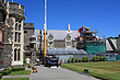
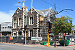
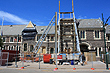
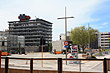
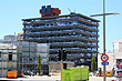
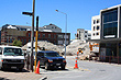
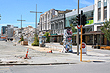
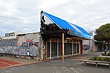
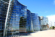
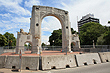
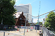
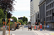
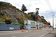
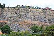
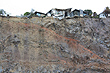
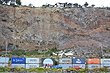
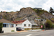
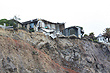
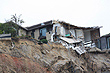
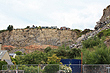
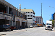
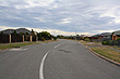
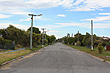
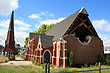
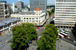
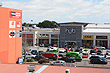
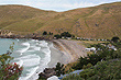
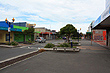
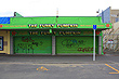
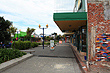
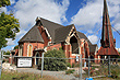
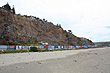
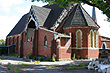 Above are photos of earthquake damage in Christchurch two years after the devastating earthquake in February 2011.
On the 4th of September 2010, Christchurch was shaken by a huge earthquake, equal in magnitude to the Haiti earthquake. Over 10,000 aftershocks ensued including the most destructive quake for the city of Christchurch. In all, the total bill for all the quakes topped NZ$ 30 billion, (that was more than US$ 25 billion).
The 2010 Canterbury Earthquake was the first quake to strike the city. It measured 7.1 on the Richter Scale and caused widespread damage to the city. No one was killed due to the time of the quake, (4:35 am). This meant that few people were in the Christchurch CBD and coupled with the earthquake being some distance away from the city, many in Christchurch felt that they got off lightly, for such a powerful quake. However, many thousands of aftershocks continued over the proceeding months.
On the 22 February 2011, a 6.3 earthquake struck the city during the busy lunch hour. The quake was a mere 10 kilometres (6 miles) away from Christchurch and at a shallow depth of 5 kilometres (3 miles). This earthquake became known as The 2011 Christchurch Earthquake. It was far more destructive and killed 185 people. Destruction of the Christchurch CBD and further widespread damage across the city was due to the shallowness and proximity of the quake, coupled with buildings that were already weakened by the Canterbury Quake. The result was the second-deadliest natural disaster in New Zealand's history. The cost to insurers was NZ$15 billion making it the third-costliest earthquake worldwide.
Immediately after this quake, significant liquefaction affected the eastern suburbs and produced more than 400,000 tonnes of silt. Liquefaction is a process that turns soil into liquid as water below the water table mixes with the soil or sand above. This exacerbates the destructive power of an earthquake because structures no longer sit on solid ground and are prone to sinking. Liquefaction was so extensive that cars were half submerged below the ground and buildings sunk in an uneven fashion. Water damage to homes was also significant.
After the 2011 Christchurch Earthquake there were a number of other significant quakes. Chief among these following quakes was the June 2011 Christchurch Earthquake. It also measured 6.3 on the Richter Scale and was preceded by a magnitude 5.9 quake. Only one person was killed due to the CBD being cordoned off from the public and damage was less partly because some structures that would likely have fallen had already fallen, been demolished, or were supported by scaffolding. However, there was still significant damage such as the historic Lyttelton Timeball Station which collapsed before dismantling work was completed. The bill to insurers for this quake alone was NZ$6 billion, (US$4.8 billion). Extensive soil liquefaction also took place.
On the 23 December 2011, a swarm of large aftershocks struck Christchurch. These quakes were a huge blow to the morale of people still living in Christchurch. For many, this was the last straw and some abandoned the city to settle elsewhere.
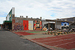
Today the rebuild of the city is underway and the earthquakes seem to have subsided and are no more numerous than other parts of New Zealand. A part of the Christchurch CBD was reopened to the public with a shopping complex made out of shipping containers. Although only temporary, ReStart as it is known is breathing new life back into the city centre. This shopping complex is creative and colourful and many want to see this shopping area become a permanent feature of the city. The rest of the CBD is in the process of being dismantled so the rebuild can take place.
Plans for a new Christchurch have already been drawn up. Known as the Central City Plan, Christchurch is to become a low level modern and artistic city with plenty of green spaces around the River Avon where buildings once stood. Areas containing abandoned homes will also become green spaces with the prospect of rebuilding homes in the future. Wildlife is already returning to some of these abandoned streets including opposums and birds. Even rare birds have been spotted.
More 'Christchurch Earthquake' photos | |||
 |  |  |  |
 | |  |  |
Author & photographer: David Johnson (Virtual New Zealand). Providing a credit or link is appreciated.
Our content: logos, site names, text, photos, and website design are protected by international copyright law.
Original versions of our photos can be purchased / licensed & web versions can be shared subject to conditions.