Taupo Region
Google Map
View Larger Map
Top Places
Taupo, Lake Taupo, Mt Ruapehu, Mt Ngauruhoe , Tongariro Crossing, Waikato River, Huka Falls, Craters of the Moon, Orakei Korako & Ohakune.
About
The Taupo area is a major volcanic area famous for thermal features, ski fields, and New Zealand's biggest lake, Lake Taupo. The region is centered around this lake with the lake itself being an ideal place for swimming, boating, and trout fishing.
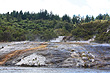
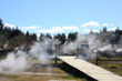
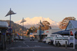
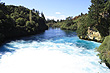
The main town in this region is also called Taupo. The town revolves around tourism and provides a wide variety of accomodation and services for travellers wanting to explore the region. Another reason for the town's popularity is its location to Auckland and Wellington. The town lies approximately half way between these two main cities making it a popular stopover. Besides the lake, there are two popular natural attractions close to the town. The powerful 'Huka Falls' and the eerie 'Craters of the Moon' volcanic reserve are a short drive or around a 1 hour walk from the town.
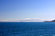
Most New Zealanders are unaware that Lake Taupo is actually a huge crater of a super-volcano. In fact Taupo was once a mountain that was destroyed by eruptions. The the biggest volcanic eruption in world in the last 5000 years took place in Taupo. It was around the year 186 AD when a huge eruption measuring 7 on the explosivity index took place. This was just short of a super-volcanic eruption. Previous to that event, about 26,500 years ago, Lake Taupo had an eruption that was many hundreds of times bigger than the 186 AD eruption. It was the world's largest and most destructive volcanic event in the last 70,000 years. This was a true super-volcanic event and measured 8 on the volcanic index. Today it is hard to believe, that such events took place as the lake is peaceful and serene and popular with tourists. If you look close enough today though, you can see evidence of this violent past with clues like the abundance of pumice stones on the lake shore and steam rising out of the lake in different spots.
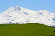
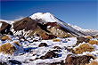
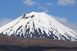
South of Lake Taupo lies scenic Tongariro National Park. This park sits on a high plateau making it colder than usual for this latitude. Heavy snowfalls each winter occur here and this supports a bustling ski industry on the slopes of the biggest volcano in the park. Called Mount Ruapehu, it is the highest peak in the North Island. Ruapehu is also located next to two other volcanoes, namely, Mt Ngauruhoe and Tongariro. All three volcanoes are still active with Ruapehu 's last eruption being in 1995/1996, Ngauruhoe in 1972, and Tongariro in 2012. Ngauruhone doubled as Mt Doom in the blockbuster trilogy, 'Lord of the Rings'.
Photo Galleries
 |  |  |  |
 |  |  |  |
 |  | ||
Video of the Central Plateau, Taupo
Travel Links
Author & photographer: David Johnson (Virtual New Zealand). Providing a credit or link is appreciated.
Our content: logos, site names, text, photos, and website design are protected by international copyright law.
Original versions of our photos can be purchased / licensed & web versions can be shared subject to conditions.