West Coast Region
Google Map
Top Places
Westland: includes, Franz Josef Glacier, Fox Glacier, Okarito, Lake Matheson, Bruce Bay, Southern Alps. Paparoa National Park, Pancake Rocks, Mt Aspiring National Park, Arthurs Pass.
About
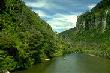
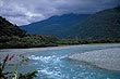
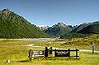
The West Coast is a rugged isolated region that starts at Kahurangi Point in the north to Awarua Point in the south, some 600 km in distance. The east of this region is bordered by the mighty Southern Alps with lush lowland rainforest disected by rivers that flow toward the wild and exposed coastline in the west. The steepness of the landscape and high rainfall results in lush vegetation, waterfalls, and also causes glaciers to exist closer to the coastline than anywhere else in the world, outside of the polar regions. Viewing glaciers from within a rainforest is certainly different to other glacial sites in the world.
A large portion of the Westcoast region is protected wilderness. National parks are common with such gems as Westland, Paparoa, Mt Aspiring and parts of the Arthurs Pass and Kahurangi national parks. The lower half of the Westcoast also forms part of the the South Westland World Heritage Area, which is one of the largest protected wilderness areas on Earth.
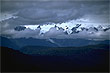
The Westcoast is isolated from the rest of the South Island because of the huge Southern Alps mountain range. This range extends for nearly 600 km which is bigger in area than the European Alps and other notable mountain ranges found on continents. There are a number of scenic passes that pierce this mountainous barrier, such as the the Buller Gorge, Arthurs Pass, and the Haast Pass which are all essential links for travellers and goods to the Westcoast.
The region is sparsely populated compared with other regions in New Zealand. Most settlements are small, but there are a few bigger towns including Hokitika, Westport, and Greymouth.
Visitors to the Westcoast find the area a mecca for tourist based activites. Plane or helicopter rides from both Franz Josef and Fox townships over the glaciers and mountains is popular. A trek up either Franz Joseph or Fox glaciers is another way to see the glaciers and surrounding mountains.
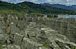
Further north from the glaciers lies Punakaiki National Park. This park is best known for the scenic and rugged Pancake Rocks and associated blowholes that put on quite a show at high tide. A paddle through nearby Pororari River by canoe shows off some of the scenic limestone landscapes clothed in lush temperate rainforest. This park is part of the natural growing range of the Nikau Palm, New Zealand's only native palm. It is also the world's most southerly palm and the only palm who's natural growing range is outside of the tropics.
One of the best alpine views in New Zealand can be seen from 'The Alpine Crossing'. This walk provides the chance to scale over the mountains from the Mt Cook National Park on the east, to the Westcoast region. It is strongly recommended that you walk this track with a guide and crampons are essential all year round.
Photo Galleries
 |  |  |  |
 | |||
Promotional Video
Travel Links
Author & photographer: David Johnson (Virtual New Zealand). Providing a credit or link is appreciated.
Our content: logos, site names, text, photos, and website design are protected by international copyright law.
Original versions of our photos can be purchased / licensed & web versions can be shared subject to conditions.