Canterbury Region
Google Map
View Larger Map
Top Places
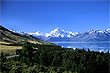
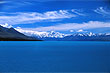
Christchurch city, Banks Peninsula & Akaroa, Mt Cook, Lake Pukaki, Kaikoura, Hanmer Springs, Arthur's Pass.
About
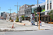
Canterbury is a region and large plain that stretches from the eastern coastline of the South Island to the Southern Alps in the west. In 2010-11, the region was hit by a number of huge earthquakes resulting in loss of lives and the destruction of over one thousand commerical buildings in the Christchurch city centre as well as thousands of homes. Overall the insurance industry equated the destruction wrought to the equivalent to eight Hurricane Katrinas. This aside, the region is open for business and tourists are welcome. Tours of the quake damaged city and its consequential rebuild are popular and helping the region and city get back on its feet.
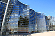
As the nations third largest city, Christchurch, is the biggest city in the South Island, and a popular gateway to exploring the scenic South Island
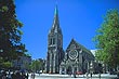
For years Christchurch has deservedly been known as the most English city outside of England. The city has many fine examples of old English buildings and cathedrals. The main river that winds its way through the city and suburbs, is called the Avon after the river of the same name in England. The climate is also similar to that of southern England with pronounced seasons and coupled with many species of trees that were originally imported from England, one could be forgiven for thinking they were actually in England. It seems ironic however that Christchurch is the furtherst place on Earth from England, and exactly twelve hours ahead of GMT.
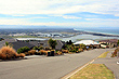
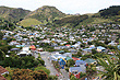
To the east of the city lies Banks Peninsula, a scenic remote area with an indented coastline that twists and turns to create many bays and inlets. There are also many vantage points which offer exceptionally good views of this area. The biggest town here is Lyttleton which is the main port for Christchurch and is connected to this city by a tunnel. You can also drive over the scenic Port Hills to get to Lyttleton. Further east is the town of Akaroa a small town settled by the French and retaining French character to this day.
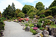
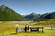
Christchurch is known as the garden city and has won The International Garden City Award. The city is also relatively close to the Southern Alps to the west meaning that there is some great skiing close by. Two major ski fields, Mt Hutt and Porter Heights are both accessible within a day trip.
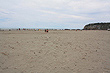
Other notable towns in Canterbury include Timaru, Methven, and Kaikoura. Kaikoura is one of the few places in the world where whales can be seen all year round. It is also the only place where the Southern Alps touch the eastern coastline as this range lies predominately in the west of the island.
Photo Galleries
 |  |  |  |
 |  |  |  |
 |  |  | |
Videos
Travel Links
Author & photographer: David Johnson (Virtual New Zealand). Providing a credit or link is appreciated.
Our content: logos, site names, text, photos, and website design are protected by international copyright law.
Original versions of our photos can be purchased / licensed & web versions can be shared subject to conditions.