Wellington Harbour - photos
 |  |  |  |
 |  |  |  |
 |  |  |  |
 |  |  |  |
 |  |  |  |
Related Photo Galleries | |||
 |  |  |  |
About Wellington Harbour
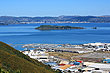
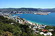
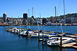
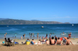
Wellington has one of the world'sgreat harbours. It has a scenic coastline with a number of beaches bays. The harbour hides a flooded volcanic crater.
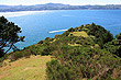
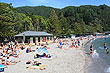
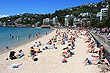
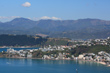
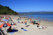
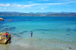
Being the harbour of a major New Zealand city, it is a natural place for boating, yachting, and windsurfing, and swimming. In the summer months many Wellingtonians flock to beaches like Oriental Bay and Scorching Bay. Other parts of the coastline are rocky and have some good coastal walks.
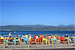
Wellingtons suburbs extend up and over the hills that surround the harbour, so many houses afford great views over the water below. On the harbours edge are some memorable cafes such as the Chocolate Fish Cafe and restaurants like Fishermans Table or the White House.
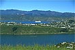
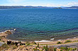
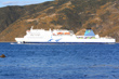
The East-West ferry connects downtown Wellington with the beautiful coastal suburb of Eastbourne at Days Bay wharf . It passes Somes Island on route which was once a quarantine station. Upon arriving at Days Bay you can head for the beach or enjoy a coffee or even grab a tasty icecream if it is a hot summers day. There are a number of good art galleries here, but if outdoor activities is your thing, then you could do a walks up into the rainforested hills behind Days Bay Beach.
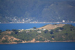
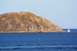
Wellington harbour originally had two entrances, the present one and a channel where Kilbirnie now lies. Miramar Peninsula was once also an island but an earthquake in 1460 linked Miramar island with the mainland. Further uplift during a major earthquake in 1855 brought Matiu/Somes Island higher above sea level, so that much of the present shore line is surrounded by cliffs. Lambton Quay the main shopping street in Wellington was part of the coastline as late as 1840.
More Photos | |||
 |  |  |  |
|  |  |  |
 |  |  |  |
 |  |  |  |
Author & photographer: David Johnson (Virtual New Zealand). Providing a credit or link is appreciated.
Our content: logos, site names, text, photos, and website design are protected by international copyright law.
Original versions of our photos can be purchased / licensed & web versions can be shared subject to conditions.