Northland Beaches - photos
 |  |  |  |
Related Photo Galleries | |||
 | |||
About Northland Beaches
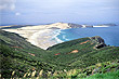
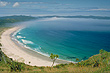
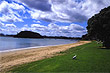
 Northland contains some of the best beaches in New Zealand and coupled with its sub-tropical climate, it is a natural holiday destination. Often called the the Far North or the Winterless North, Northland sits between the Tasman Sea and the Pacific Ocean. The land itself consists of farmland and small settlements. Native forests still cover half of the land including ancient Kauri forests which have trees that contain the largest volume of wood in the world.
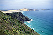
The western coastline of the region is dominated by a few big beaches including the inaccurately named Ninety Mile Beach, which is actually 88 km long (54 miles). The east coast on the Pacific side is more irregular and is dotted with scenic bays, peninsulas, and some equisite white sand beaches.
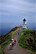
The northernmost point is often thought to Cape Reinga when it is actually the Surville Cliffs, close to North Cape. However, New Zealand also owns the Kermadec Island chain that lies between the North Island and the South Pacific nation of Tonga to the north. According to Māori mythology both Cape Reinga and Spirits Bay is where the souls of the dead depart for the afterlife.
Author & photographer: David Johnson (Virtual New Zealand). Providing a credit or link is appreciated.
Our content: logos, site names, text, photos, and website design are protected by international copyright law.
Original versions of our photos can be purchased / licensed & web versions can be shared subject to conditions.