Lake Hawea - photos
 |  |  |  |
About Lake Hawea
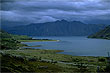
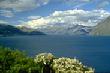
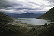
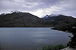
 Lake Hawea in the Central Otago region sits at an altitude of 348 metres above sea level. Its area is 141 km² (87 square miles), and its depth 392 metres. At it greatest length it is 35 km (21 miles).
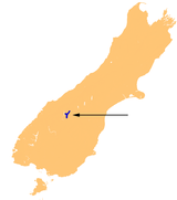
The lake resides in a huge glacial valley next to another valley that contains Lake Wanaka. A mere 1 km separates these lakes at their closest point.
Mountains surround Lake Hawea with a small area of flat land around the lake at the southern end where the small settlement of Hawea is located.
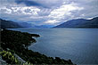 The lake is a popular summer holiday spot as it allows swimming. Fishing and boating are also popular year round. Fast-flowing rivers in the mountains provide adventure tourism activities includeing: skiing, jetboating, climbing, and trekking.
Author & photographer: David Johnson (Virtual New Zealand). Providing a credit or link is appreciated.
Our content: logos, site names, text, photos, and website design are protected by international copyright law.
Original versions of our photos can be purchased / licensed & web versions can be shared subject to conditions.