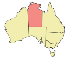
Northern Territory
Google Map
View Larger Map
Top Places
Darwin, Alice Springs, Kakadu National Park, Uluru, Kata Tjuta, Mt Conner, Kings Canyon, Katherine Gorge, Arnhem Land.
About
 The Northern Territory is huge and sparsely populated. It lies in the tropical climatic zone in the north to an arid/desert climate in the south. The northern coast is situated on Asia's doorstep.
The vegetation in this state ranges from tropical rainforest in the north which increases toward arid landscapes as you venture toward the centre of Australia. The majority of this territory is made up of outback and stations, the latter being huge rural properties, some bigger than some countries.
 The northern part of this state is known as
the 'Top End' to the locals. There are only two seasons here, the Wet season
and the Dry.
The northern part of this state is known as
the 'Top End' to the locals. There are only two seasons here, the Wet season
and the Dry.
Darwin is the capital city of this state. It is located on the northern coast in what is called the 'Top End'. It is a tropical city and the last Australian city before heading across the Arafura sea into Asia. Although the city is modern, peacful, and laid back it hides a destructive past. In WWII the Japanese bombed Darwin and on Christmas Day, 1974 a powerful cyclone devastated the city. While everyone else was celebrating Christmas, Cyclone Tracy wreaked havok on Darwin killing 71 people and destroying 80 percent of homes and 70 percent of the buildings in the CBD. It is hard to imagine that such events ever took place given that the city is so peacful and laid back today.
 To the west of Darwin lies a huge World Heritage
area called Kakadu National Park which is 3.2 million acres in area. The park
is renown for its unique bird life and rugged tropical beauty. It also has
cultural importance to the Aborigine people. Aboriginal
paintings can be found on rocks and cave walls here more than anywhere else in Australia. In fact Kakadu has the world'sgreatest display of ancient art.
To the west of Darwin lies a huge World Heritage
area called Kakadu National Park which is 3.2 million acres in area. The park
is renown for its unique bird life and rugged tropical beauty. It also has
cultural importance to the Aborigine people. Aboriginal
paintings can be found on rocks and cave walls here more than anywhere else in Australia. In fact Kakadu has the world'sgreatest display of ancient art.
This park is also crocodile country. Parts of the movie "Crocodile Dundee" were filmed here. The landscape contains spectacular waterfalls which are best viewed during the wet season. Kakadu extends from the escarpment of Arnhem Land to the east, to the tidal flats of Van Dieman Gulf in the north and south to almost reach Katherine Gorge.
Katherine Gorge is a popular tourist attraction at the Top End. It is the result of the Katherine River winding its way through some very rugged Australian landscape. One of the best ways to see the gorge is to hire a canoe and admire the sheer cliff walls and Australian fauna.
As you head down the main highway,( known as "The Track"), you will start to notice the landscape becoming increasingly arid. If you travel far enough you will enter the vast desert areas that Australia is famous for. Mataranka Springs being the exception is an oasis created by an abundance of underground water which surfaces here through huge vents. The springs themselves are refreshing to swim in and are warm enough to stay in for hours.
If you continue to head south you will eventually come to Alice Springs the second biggest city in the Northern Territory. Alice Springs is a modern outback city that still retains it's pioneering charm. Surrounded by the Mac Donnell Ranges and endless desert, this area of Australia is called the' Red Centre', due to the colour of the sand. Occasionally this sea of red sand dunes is broken by white salt from dried out salt lakes or large rocky outcrops.
The Australian desert has a surprising amount of flora and fauna. You won't find cactus in the deserts of Australia, but you will find many Eucalyptus trees as well as other bush, shrub, and flower species. Like the rest of Australia there is also an abundance of colourful birds. In this part of Australia, it is very easy to spot kangaroos and emus due to less vegetation obscuring your view. You may even see a snake or a goanna – a type of giant lizard.
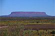
Ayers Rock the largest monolith in the world is located in the south of the state and almost the dead centre of Australia. 'The Rock' as it is affectionately known is probably the country's most famous geographical landmark, it is about a half day drive from Alice Springs. Further to the west of Ayers Rock are a group of 27 domes called the Olgas which are even more spectacular.
If you continue south along the main highway you will eventually cross into South Australia. To the west is Western Australia and to the east is Queensland. To the north is the Arafura Sea and the nearest land from there are islands that make up neigbouring Indonesia.
Photo Galleries
 | |||
Promotional Video
Travel Links
Author & photographer: David Johnson (Virtual Australia). Providing a credit or link is appreciated.
Our content: logos, site names, text, photos, and website design are protected by international copyright law.
Original versions of our photos can be purchased / licensed & web versions can be shared subject to conditions.