Western Australia
Google Map
View Larger Map
Top Places
Perth, Rottnest Island, The Pinnacles, Ningaloo Reef, Shark Bay, The Kimberley , Purnululu National Park, Broome, Margaret River.
About
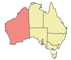
 Western Australia is Australia's largest state, covering the western third of the continent which totals a huge 2,645,615 km2 or 1,021,478 sq mi. This is approximately 3.5 times the size of Texas and makes Western Australia the second largest state/province/national region in the world.
The capital city Perth, is one of the most isolated metropolitan areas on Earth. The nearest city to Perth with a population over 1 million is Adelaide in South Australia, which is 2,104 kilometres (1,307 mi) away. Perth is physically closer to East Timor and Jakarta, Indonesia, than it is to Sydney, Melbourne, and Brisbane. It is the antipode of Hamilton in Bermuda.
 Perth is known as Australia's sunniest city and enjoys a Mediterranean climate.
In the peak of summer, the temperature can be unbearable as it reaches well into the 40s (celsius), but the winters are mild.
Perth is known as Australia's sunniest city and enjoys a Mediterranean climate.
In the peak of summer, the temperature can be unbearable as it reaches well into the 40s (celsius), but the winters are mild.
The city is organized and modern and has many parks and superb beaches for swimming and surfing. The beautiful Swan River flows through Perth and many Perth residents define themselves as living either north of the river or south of the river. The river drains into the Indian Ocean at the Port of Fremantle, a beautiful town with many historic buildings.
 If you head south from Perth, you will come
across many pleasant towns like Albany and Esperance. In this general area are a number of nice beaches and some superb surfing particularly at Margaret
River. South West Australia also contains areas of Karri Forest which which contain some
of the tallest trees in the world.
If you head south from Perth, you will come
across many pleasant towns like Albany and Esperance. In this general area are a number of nice beaches and some superb surfing particularly at Margaret
River. South West Australia also contains areas of Karri Forest which which contain some
of the tallest trees in the world.
If you head north out of Perth it doesn't take long before you enter the endless Outback. The top one third of Western Australia lies in the tropical zone and you can even find tropical rainforests fringing the northern coastline here. Below that you will find vast areas of grasslands (savanna) which look like the game reserves you find in Africa, with the exception of an innumerable amount of huge ant hills dotting the landscape intermingled with Australian fauna including kangaroos and emu.
Further south lie the deserts that Australia is famous for. In fact the Australian deserts are the biggest in the world outside of the Sahara. The main deserts here are the Simpson Desert, The Great Sandy Desert, The Great Victoria Desert, and the Nullabor Plain. Nullabor means "no trees" in Latin. These deserts come to life each Spring with the most spectacular and colourful show of wild flowers on Earth.
Western Australia also has more coastline than any other state and much of this coastline is pure white sand with sparkling clear and warm inviting water. The catch is that many of these idyllic beaches in the north of the state are infested with sharks and other nasties. There are still safe beaches here where you can swim and bathe, but local knowledge is important when deciding where to swim
One of the best beaches in North Western Australia is Cable Beach, located in a small outback town called Broome. This town is marketed as an alternative to Bali in Indonesia, which is a popular overseas destination for residents of Perth, due to its close proximity with that city.
North West Cape is famous for Ningaloo Reef, which is just as spectacular as the Great Barrier Reef in Queensland, although not as extensive. The Reef may be smaller but there is also less people and it easy to access .This area also has some superb beaches and lagoons.
Another area of interest on the west coast is a place called Shark Bay. This World Heritage area is very scenic, but most come here to get up close and personal with dolphins that frequent here.
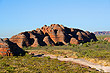
Western Australia has some of the weirdest looking landscape on Earth. One such area Purnululu National Park is home to the Bungle Bungles, a vast area of dome shaped mountains of stone which are orange in colour and lined with black stripes, caused by a type of lichen that grows on certain layers of rock. It is quite incredible to note that the area was discovered in the 1980s and stands as a testimony to the vast unexplored areas that still exist in this state.
Cervantes National Park or the Pinnacles as they are more commonly known, is another strange work of nature. In prehistoric times this area was once covered in forest but as Australia moved north due to continental drift this forest moved into the arid zone and the forest died. The dead trees were replaced by sand as they wasted away and today you can see the hundreds of stone pinnacles that replaced the trees to become a petrified forest.
Everything about Western Australia is big. If you travel along the main highway for example it is common to see Road Trains transporting goods up and down the state. These Road Trains are trucks with 2 or 3 sometimes 4 full trailers on the back. If you visit one of the open cast mines in the north you will see the world biggest earth moving machines, trucks with houses in them, and trains that are kilometers in length.
Following the main highway north will lead you to the Northern Territory which is northeast of this state. South Australia lies to the southeast. Beyond the western shoreline is the Indian Ocean and to the south of the state lies the Great Southern Ocean. The nearest landmass to the south is Antarctica and Indonesia lies due north.
Photo Galleries
 | |||
Promotional Video
Travel Links
Author & photographer: David Johnson (Virtual Australia). Providing a credit or link is appreciated.
Our content: logos, site names, text, photos, and website design are protected by international copyright law.
Original versions of our photos can be purchased / licensed & web versions can be shared subject to conditions.