Port Fairy Victoria - photos
 |  |  |  |
Related Photo Galleries | |||
 |  |  |  |
About Port Fairy Victoria
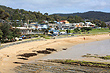
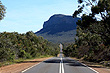
Port Fairy is a coastal town situated on the southern coastline of Victoria at Port Fairy Bay and extends around Moyne River. To the east is the city of Warrnambool and to the north lies rural countryside that eventually touches The Grampians, a scenic area of mountains.
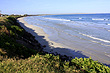
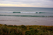
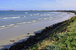
The town's economy is based on tourism, fishing, and whale watching. The coastline has many beaches and a number of good surf spots like Old Passage, the Lighthouse, and East Beach.
The township has an interesting history with strong Irish heritage. Immigrants were lured to the area because of available land that was rich in volcanic soil, making it ideal for growing crops like potatoes and onions.
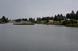
Today there are over 70 buildings of historic significance in town with many boats moored along Moyne River just behind the scenic coastline. This mixture of history, boating, and beachlife gives Port Fairy its unique character.
Author & photographer: David Johnson (Virtual Australia). Providing a credit or link is appreciated.
Our content: logos, site names, text, photos, and website design are protected by international copyright law.
Original versions of our photos can be purchased / licensed & web versions can be shared subject to conditions.