Taranaki Region
Google Map
View Larger Map
Top Places
Egmont National Park / Mt Taranaki, New Plymouth, Pukekura Park, Taranaki coastline.
About
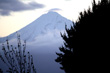
New Plymouth is the major commercial centre for the Taranaki region. To the east of this city lies Mt Taranaki an iconic feature that can be viewed from almost anywhere in the region. This mountain is a spectacular conical shaped volcano which dominates the landscape. The volcano rises ubruptly to 2518 metres out of the surrounding plain and is located as little as a 30 minute drive from the coast. Mt Taranaki actually doubled as Mt Fuji in the movie, 'The Last Samurai'.
The volcano within Egmont National Park and is surrounded by dense temperate rain forest. The vegetation changes as gain altitude to eventually you reach areas dominated by an alpine grasses followed by rock surfaces that are often covered in snow. The national park also encompasses the nearby Kaitake Ranges giving a total area of 24,000 hectares. On the slopes of the volcano, is a ski field called Manganui, the ski area in the North Island outside of nearby Mt Ruapehu.
Egmont National Park has a number of walks ranging from lowland treks through rainforest to alpine treks. One of the best is the steep four hour walk to Fantham's Peak. Another more challenging walk called 'The Mountain Circuit', circumnavigates the volcano and takes 3 to 4 days in summer to complete. Three roads also exist that take you part the way up different sides of the mountain with walking tracks that take you further.
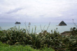
The Taranaki Region is also famous for its surf beaches and rugged coastline.
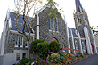
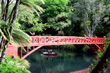
The main city New Plymouth has arguably the best botanic gardens in the country of any city. Pukekura Park is an oasis of nature and flora. Covering over 50ha, it has areas of native bush, exotic plant collections and trees, gardens, and lakes. Walking tracks cut through the scenic landscapes and open up to small parks ideal for picnics.
Photo Galleries
 |  |  |  |
Promotional Video
Travel Links
Author & photographer: David Johnson (Virtual New Zealand). Providing a credit or link is appreciated.
Our content: logos, site names, text, photos, and website design are protected by international copyright law.
Original versions of our photos can be purchased / licensed & web versions can be shared subject to conditions.