Northland Region
Google Map
View Larger Map
Top Places
Bay of Islands, Russell, Paihia, Cape Reinga, Ninety Mile Beach, Spirits Bay, and Waipoua Forest.
About
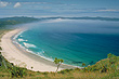
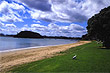
Northland is the only region in New Zealand with a sub-tropical climate. Summer is from November to early April with the hottest months being January and February. The top of Northland known simply as the 'Far North' is famous for beaches and in particular the longest beach in New Zealand, called the 'Ninety Mile Beach'. It covers the entire western coast of the Far North and has huge sand dunes which make parts of this coastline resemble the Sahara Desert. Over on the more sheltered east coast, the coastline is indented with many idyllic sandy beaches and bays, which include such gems as Karikari beach, Great Exhibition Bay which is claimed to have the purest deposit of silica sand in the world, and sacred Spirits Bay.
Further south of the Far North but still on the east coast, is one of New Zealand's most popular tourist attractions, The Bay of Islands. Boat trips available from the towns of Paihia and Russell and will take you out to see some of the 150 sub-tropical islands dotted in the bay.
The town of Waitangi is located here and has special importance to New Zealand because it is here that the Treaty of Waitangi was signed in 1840. This treaty is the the founding document of the nation.
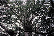
Another major attraction in the Northland are the ancient Kauri forests. These forests contain the mightiest trees in New Zealand which rate amongst some of the biggest and oldest trees in the world. These forests are located on the western side of Northland aptly named the Kauri Coast.
Photo Galleries
 |  |  | |
Promotional Video
Travel Links
Author & photographer: David Johnson (Virtual New Zealand). Providing a credit or link is appreciated.
Our content: logos, site names, text, photos, and website design are protected by international copyright law.
Original versions of our photos can be purchased / licensed & web versions can be shared subject to conditions.