Manawatu-Wanganui Region
Google Map
View Larger Map
Top Places
Palmerston North, Wanganui, Rangitikei River, Whanganui River, Manawatu Gorge, Tararua Range, Ruahine Range.
About
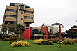
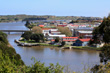
Manawatu-Wanganui region is located just north of the Wellington region and east of the Wairarapa. Palmerston North is the biggest city here and a hub for educational and research institutions including Massey University. The other main city in the region is Wanganui, which is situated on the banks of the Whanganui River and on the west coast. Besides these two small cities, there are a number of large towns like Otaki, Foxton, Levin, Taihape, and Woodville.
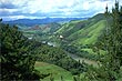
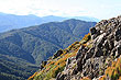
The region is basically a large rural plain used for sheep and dairy farming. It has a coastline with some beaches to the west and the major portion of the Tararua and Ruahine mountain ranges to the east. These mountains offer a number of extensive cross-country walks that cover low altitiude rainforest up to sub-alpine tussock country with seasonal snow.
There are three main rivers in the region. The Whanganui River (290 km), Manawatu River (182 km) and Rangitikei River (241 km). Popular activites on these rivers include white water rafting, fly fishing, and commercial bungee jumping. Of these rivers, the Whanganui is the only one that is navigable by larger boats and some of the surrounding area is protected under the name, Whanganui National Park which consists of lowland temperate rainforest.
The scenic Manawatu Gorge divides the Tararua and Ruahine ranges. State Highway 3 runs through the gorge about 20 minutes after passing Palmerston North on the Manawatu side. It runs through to the town of Woodville in the Wairarapa. The gorge offers great scenery including steep hills, canyon walls, temperate rainforest, and views of the Manawatu River. There are a number of places you can park allowing for easy exploration of the area. Barbeques, walks, and some longer treks are available.
Photo Galleries
 |  |  |  |
 |
Promotional Video
Travel Links
Author & photographer: David Johnson (Virtual New Zealand). Providing a credit or link is appreciated.
Our content: logos, site names, text, photos, and website design are protected by international copyright law.
Original versions of our photos can be purchased / licensed & web versions can be shared subject to conditions.