Waikato Region
Google Map of Waikato Region
View Larger Map
Top Places
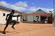
Hamilton, Waitomo Caves, Waikato River, Raglan, Matamata, and Hobbiton.
About
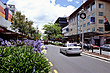
Waikato is the name of a region that sits below the populous Auckland Region. 'The Waikato' as it is known contains New Zealand's biggest river, also called 'The Waikato'. On the banks of this river is Hamilton, the region's biggest city. It is New Zealand's biggest inland city and fourth biggest city in the country. Hamilton is very close to Auckland, with the possibility that it could be assimilated by Auckland's suburban sprawl in decades to come.
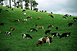
The Waikato is known as one of the richest pastoral areas in the world. It is a huge fertile basin that was created by the Waikato River ideal for agriculture and farming. Besides agriculture, tourism and hydroelectricity are also big industries.
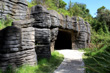
Beneath the pastoral plains of the Waikato lie the Waitomo Caves system which contains over 300 caves. Waitomo offers cave exploration among stunning examples of stalactites and stalagmites, rafting down underground rivers, and viewing glow worms.
On the coast is the town of Raglan. It has one of the world's great surf breaks due to its long wave rides. Raglan is one of the surfing's world's competition stops. The surf and beaches are located in the Tasman Sea, the main body of sea between New Zealand and Australia. This coast has three large harbours: Raglan, Aotea, and Kawhia Harbour.
Behind the coastal area lies the Hakarimata Range. To the east of this range lies a large floodplain which is used mainly as farmland for both dairy and cattle, as well as crops. Cambridge a town in this area is famous for its thoroughbred stables. In the north near Te Kauwhata is an area of vineyards and wineries.
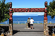
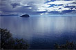
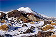
Photo Galleries
 |  |  |  |
 |  |  |  |
Promotional Video
Travel Links
Author & photographer: David Johnson (Virtual New Zealand). Providing a credit or link is appreciated.
Our content: logos, site names, text, photos, and website design are protected by international copyright law.
Original versions of our photos can be purchased / licensed & web versions can be shared subject to conditions.