Taranaki Coastline - photos
 |  |  |  |
 |  |  |  |
Related Photo Galleries | |||
 |  |  |  |
About Taranaki Coastline
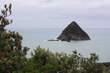
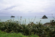
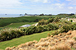
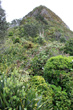
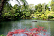
The Taranaki coastline is famed for its surf and rugged scenic coast. Situated on the west coast of the North Island and surrounding Mt Taranaki, it allows you to surf in the Pacific Ocean while looking at the snow capped peak of a huge volcano. There are two large bays, north-west and south-west of Cape Egmont. They are simply named North Taranaki Bight and South Taranaki Bight.
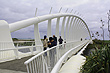
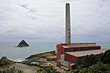
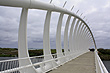
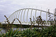
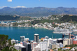
The best way to view the coastline is to go on the award-winning Coastal Walkway. This thirteen kilometre pathway spans the small city of New Plymouth and gives views of the coast. Starting at Hickford Park, Bell Block to the east is heads south to Port Taranaki and Paritutu Rock providing views of the Sugar Loaf Islands. Te Rewa Rewa bridge is one of the highlights. This steel arch bridge frames Mt Taranaki as you walk across.
Author & photographer: David Johnson (Virtual New Zealand). Providing a credit or link is appreciated.
Our content: logos, site names, text, photos, and website design are protected by international copyright law.
Original versions of our photos can be purchased / licensed & web versions can be shared subject to conditions.