Mt Tarawera - photos
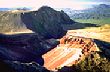 | 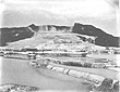 |  |  |
Mount Tarawera is a volcanic mountain near Rotorua in the North Island of New Zealand. It consists of a series of rhyolitic lava domes that were fissured down the middle by an explosive basaltic eruption in 1886, which killed over a hundred people. The peaks are Ruawahia Peak, Tarawera Peak, and Wahanga Peak. The summit is at 1111 metres.
The crater of the volcano is a series of chasms, running for 17 kilometres northeast-southwest. The volcano is surrounded by a series of lakes, many of which were created or drastically altered in the 1886 eruption. These lakes include Lakes Tarawera, Rotomahana, Rerewhakaaitu, Okataina, Okareka, Tikitapu (Blue Lake) and Rotokakahi (Green Lake). The Tarawera River runs northeastwards across the northern flank of the mountain from Lake Tarawera.
Author & photographer: David Johnson (Virtual New Zealand). Providing a credit or link is appreciated.
Our content: logos, site names, text, photos, and website design are protected by international copyright law.
Original versions of our photos can be purchased / licensed & web versions can be shared subject to conditions.